
How can a historical library collection help us understand Long Island’s changing landscape, while also testing the capabilities of emerging artificial intelligence technologies? During a six-week Research Experience for Undergraduates (REU) program hosted by Stony Brook University’s AI Innovation Institute (AI3), students Walter Ramos, Olivia Nehring, and Ashraf Sangi worked with Nicholas Johnson (Director of Artificial Intelligence), Hojun Son (AI Research Scientist), Victoria Pilato (Associate Director of Digital/AI Ethics & Policy), John Fitzgerald (Associate Director, IT/AI Operations), and Sung-Gheel Jang (Director of the Geospatial Center) to investigate these questions. Their project drew upon the Stony Brook University Libraries’ Historical Long Island Black-and-White Aerial Photographs Collection, which contains nearly 700 historical images documenting communities and landscapes across the region.
Using historical photographs from 1938, 1947, and 1970, the students examined how agricultural and rural landscapes became increasingly urban and suburban. They learned QGIS software and manually georeferenced selected photographs by matching coastlines, road intersections, buildings, and other recognizable features with a modern basemap. Not only did this work prepare the images for analysis, it also created valuable new geospatial metadata for the collection. By establishing where each photograph belongs in geographic space, the students made it possible to align the historical images with modern data and opened new opportunities for researchers to discover, compare, map, and reuse these important primary sources.
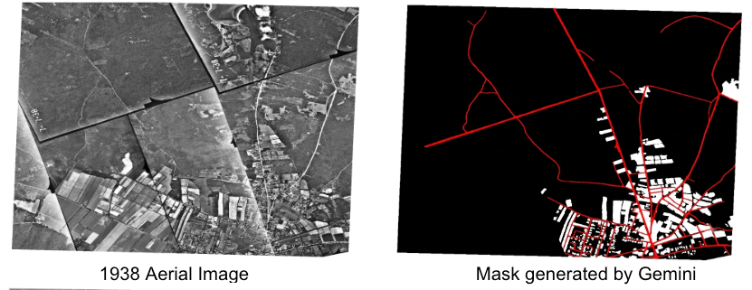
Figure 1: A 1938 aerial images taken over Long Island (left) and the land-use classified by Gemini (right). In the mask image, red lines indicate roads, white areas indicate urban spaces, and black areas represent non-urban spaces.
The students then explored how large language models with computer-vision capabilities could help identify urban areas, roads, and non-urban land in the historical imagery. Using AI-generated classifications, they documented substantial development in the study areas including an increase in urban area from 8.5 percent in 1938 to 33.3 percent in 2025. The project also offered a practical assessment of AI’s present limitations in which models sometimes misidentified roads and urban features.
This project illustrates the growing role of Stony Brook University Libraries as a leader in AI-enabled research and education. By bringing together distinctive historical collections, geospatial expertise, local computing resources, and emerging AI methods, the Libraries helped students develop meaningful research findings while critically evaluating new technologies.