On April 12, Dr. Dan Davis led an engaging talk ““Mapping the Geology of Long Island Through Time at and Below the Surface” in the Special Collections Seminar Room marking the first lecture of the spring 2017 University Libraries STEM Speakers Series.
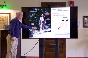
Dr. Davis discussed the landforms of Long Island which resulted from glaciers, wind, and storms. The high point of Tabler Quad in the hilly Stony Brook campus was shaped by the advance of the glaciers whereas the Fire Island Inlet was caused by wind and storms. Dr. Davis also emphasised that historical maps play an important role for mapping an event over time. The combination of historical maps and Ground Penetrating Radar (GPR) help pinpoint in 4-D (3D plus time) the formation of the Walking Dunes of Napeague over the last few centuries. Additionally, the newly-installed Optically Stimulated Luminescence (OSL) lab in the Department of Geoscience will greatly enhanced the dating of recent geological events.