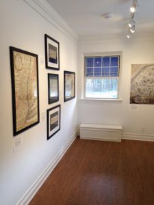
The map selections (facsimiles) have a broad historical range. A hand colored map appeared in Willem and Joan Blaeu’s Theatrum orbis terrarum, sive, Atlas Novus, 1640 and other editions. The map pictured left of New Netherland and New England derives from Adriaen Block’s 1614 hand-drawn chart, which defined Manhattan and Long Island as islands after Block’s explorations of Long Island Sound and coastal waters up to Cape Cod, and served as the cornerstone for Dutch claims to the lower Northeast. It is decorated with deer, foxes, bears, egrets, rabbits, cranes, turkeys, beavers, polecats and otters, suggesting to fur traders the economic potential of region. Another work featured is a map of Suffolk County from Atlas of the State of New York published in 1829, the second atlas ever created for a state. An 1899 map issued by the Long Island Railroad Co. shows roads, paths, runs, and hotels for cyclists who wished to travel Long Island and “lay out a trip intelligently.” Such maps were produced to promote tourism as well as to encourage people to relocate to Long Island. A 1978 map is a comically detailed rendering of the Stony Brook University campus that took graphic artist Larry Auerbach almost a year to complete. It was commissioned to help orient students to the campus.
The Reboli Center for Art and History is located in the landmark building at 64 Main Street, Stony Brook, New York, which is its headquarters. Admission to the exhibitions is free! Open Tuesday to Saturday from 11am – 5pm and Sunday 1pm – 5pm.
Kristen Nyitray
Latest posts by Kristen Nyitray (see all)
- SBU Libraries Hosts Javits Family and Panel Discussion Celebrating $1 Million Gift and Senator Javits’ Legacy - September 29, 2025
- Culper Spy Day 2025: 11th Anniversary Re-Cap - September 27, 2025
- Join Us on the Art Crawl on Friday, 9/26 between 2-5pm - September 18, 2025

![Willem Janszoon Blaeu (1571-1638) Nova Belgica et Anglia Nova. [Amsterdam]: Blaeu, ca. 1635.](http://library.stonybrook.edu/wp-content/uploads/2017/01/discover_maps_blaue_500-241x300.jpg)


