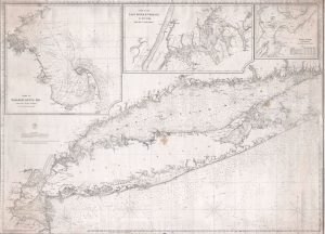
Special Collections has acquired an extremely rare 1860 nautical chart or maritime map of Long Island by Brooklyn-based publisher Charles Copley. Copley’s chart covers Staten Island to Montauk, inclusive of the Connecticut coast, Long Island Sound, Long Island, New York City, and parts of adjacent New Jersey and Rhode Island. The map features three large insets detailing Cape Cod, New York City’s East River, and New York City’s Hell Gate.
Copley published this map at the height of his career; it incorporates the best hydrographic information regarding New York and Long Island available at the time. It also includes the most advised shipping routes, countless depth soundings, shading, notes on light houses and buoys, and land information. With its three large insets, this chart would have been extremely valuable for those using the lucrative New York – Boston route. Privately published, it bears a note claiming that Copley had ‘special permission’ from the Secretary of the Treasury to use government information compiled by the United States Coast Survey. To this end, he refers to his business the ‘Hydrographic Office’ and incorporates a logo that is a clear mimicry of the Coast Survey insignia.
Charles Copley was an American nautical chart and globe publisher based in Brooklyn. He was born in England, emigrated to the United States in the 1840s, and became a citizen in 1844. Copley’s earliest work is associated with the firm of E. and G. W. Blunt; his name appears as cartographer or engraver on several of Blunt’s c. 1840 charts. Around 1847, Copley began publishing independently and advertising himself as an engraver and map publisher. Most of his independent work was published in the 1850s.
Kristen Nyitray
Latest posts by Kristen Nyitray (see all)
- Exploring Early Texts & Shakespeare’s World: EGL 345 Visits Special Collections - December 3, 2025
- Pictures from the Past: Exploring Stony Brook 50 Years Ago - November 3, 2025
- Special Collections and University Archives at the LGBTQ+ History Month Opening Celebration - October 31, 2025


